# geojson2h3
[](https://github.com/uber/geojson2h3/actions)
[](https://coveralls.io/github/uber/geojson2h3?branch=master)
[](LICENSE)
[](https://badge.fury.io/js/geojson2h3)
The `geojson2h3` library includes a set of utilities for conversion between GeoJSON polygons and [H3 hexagon indexes](https://h3geo.org), using [h3-js](https://github.com/uber/h3-js).
- Post **bug reports or feature requests** to the [Github Issues page](https://github.com/uber/geojson2h3/issues)
- Ask **questions** by posting to the [H3 tag on StackOverflow](https://stackoverflow.com/questions/tagged/h3)
## Installation
```
npm install geojson2h3
```
## Example Usage
```javascript
import geojson2h3 from 'geojson2h3';
const polygon = {
type: 'Feature',
geometry: {
type: 'Polygon',
coordinates: [[
[-122.47485823276713, 37.85878356045377],
[-122.47504834087829, 37.86196795698972],
[-122.47845104316997, 37.86010614563313],
[-122.47485823276713, 37.85878356045377]
]]
}
};
const hexagons = geojson2h3.featureToH3Set(polygon, 10);
// -> ['8a2830855047fff', '8a2830855077fff', '8a283085505ffff', '8a283085506ffff']
const feature = geojson2h3.h3SetToFeature(hexagons);
// -> {type: 'Feature', properties: {}, geometry: {type: 'Polygon', coordinates: [...]}}
```
## API Reference
## geojson2h3
* [geojson2h3](#module_geojson2h3)
* [.featureToH3Set(feature, resolution, [options])](#module_geojson2h3.featureToH3Set) ⇒ Array.<String>
* [.h3ToFeature(hexAddress, [properties])](#module_geojson2h3.h3ToFeature) ⇒ Feature
* [.h3SetToFeature(hexagons, [properties])](#module_geojson2h3.h3SetToFeature) ⇒ Feature
* [.h3SetToMultiPolygonFeature(hexagons, [properties])](#module_geojson2h3.h3SetToMultiPolygonFeature) ⇒ Feature
* [.h3SetToFeatureCollection(hexagons, [getProperties])](#module_geojson2h3.h3SetToFeatureCollection) ⇒ FeatureCollection
* * *
### geojson2h3.featureToH3Set(feature, resolution, [options]) ⇒ Array.<String>
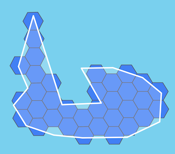
Convert a GeoJSON feature to a set of hexagons. *Only hexagons whose centers
fall within the feature will be included.* Note that conversion from GeoJSON
is lossy; the resulting hexagon set only approximately describes the original
shape, at a level of precision determined by the hexagon resolution.
If the polygon is small in comparison with the chosen resolution, there may be
no cell whose center lies within it, resulting in an empty set. To fall back
to a single H3 cell representing the centroid of the polygon in this case, use
the `ensureOutput` option.
**Kind**: static method of [geojson2h3](#module_geojson2h3)
**Returns**: Array.<String> - H3 indexes
| Param | Type | Description |
| --- | --- | --- |
| feature | Object | Input GeoJSON: type must be either `Feature` or `FeatureCollection`, and geometry type must be either `Polygon`, `MultiPolygon`, `Point`, or `MultiPoint`. |
| resolution | Number | Resolution of hexagons, between 0 and 15 |
| [options] | Object | Options |
| [options.ensureOutput] | Boolean | Whether to ensure that at least one cell is returned in the set |
* * *
### geojson2h3.h3ToFeature(hexAddress, [properties]) ⇒ Feature
Convert a single H3 hexagon to a `Polygon` feature
**Kind**: static method of [geojson2h3](#module_geojson2h3)
**Returns**: Feature - GeoJSON Feature object
| Param | Type | Description |
| --- | --- | --- |
| hexAddress | String | Hexagon address |
| [properties] | Object | Optional feature properties |
* * *
### geojson2h3.h3SetToFeature(hexagons, [properties]) ⇒ Feature
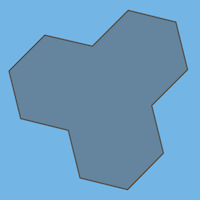
Convert a set of hexagons to a GeoJSON `Feature` with the set outline(s). The
feature's geometry type will be either `Polygon` or `MultiPolygon` depending on
the number of outlines required for the set.
**Kind**: static method of [geojson2h3](#module_geojson2h3)
**Returns**: Feature - GeoJSON Feature object
| Param | Type | Description |
| --- | --- | --- |
| hexagons | Array.<String> | Hexagon addresses |
| [properties] | Object | Optional feature properties |
* * *
### geojson2h3.h3SetToMultiPolygonFeature(hexagons, [properties]) ⇒ Feature
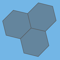
Convert a set of hexagons to a GeoJSON `MultiPolygon` feature with the
outlines of each individual hexagon.
**Kind**: static method of [geojson2h3](#module_geojson2h3)
**Returns**: Feature - GeoJSON Feature object
| Param | Type | Description |
| --- | --- | --- |
| hexagons | Array.<String> | Hexagon addresses |
| [properties] | Object | Optional feature properties |
* * *
### geojson2h3.h3SetToFeatureCollection(hexagons, [getProperties]) ⇒ FeatureCollection
Convert a set of hexagons to a GeoJSON `FeatureCollection` with each hexagon
in a separate `Polygon` feature with optional properties.

**Kind**: static method of [geojson2h3](#module_geojson2h3)
**Returns**: FeatureCollection - GeoJSON FeatureCollection object
| Param | Type | Description |
| --- | --- | --- |
| hexagons | Array.<String> | Hexagon addresses |
| [getProperties] | function | Optional function returning properties for a hexagon: f(h3Index) => Object |
* * *
## Development
The `geojson2h3` library uses `yarn` as the preferred package manager. To install the dev dependencies, just run:
yarn
To run the tests in both native ES6 (requires Node >= 6) and transpiled ES5:
yarn test
To format the code:
yarn prettier
To rebuild the API documentation in the README file:
yarn build-docs
## Contributing
Pull requests and [Github issues](https://github.com/uber/geojson2h3/issues) are welcome. Please include tests for new work, and keep the library test coverage at 100%. Before we can merge your changes, you must agree to the [Uber Contributor License Agreement](http://cla-assistant.io/uber/geojson2h3).
## Legal and Licensing
The `geojson2h3` library is licensed under the [Apache 2.0 License](https://github.com/uber/geojson2h3/blob/master/LICENSE).