# ol-opacity
ol-opacity is a OpenLayers plugin that makes multiple tile layers transparent.
[OpenLayers Plugins](https://openlayers.org/3rd-party)
[npm](https://www.npmjs.com/package/ol-opacity)
Browser Support
- Chrome
- Firefox
- Safari
## Usage
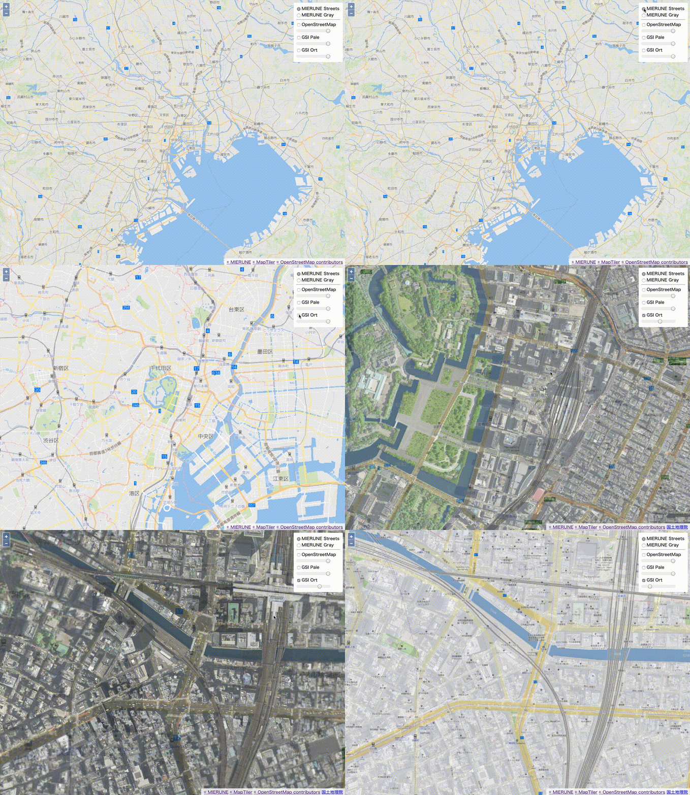
### Demo
[demo](https://dayjournal.github.io/ol-opacity)
### Option
```javascript
// OpacityControl Option
// Baselayers settings
baseLayers: new LayerGroup({
title: 'BaseLayer',
id: 'baseLayer',
layers: [
m_streets,
m_gray
]
})
// Overlayers settings
overLayers: new LayerGroup({
title: 'OverLayer',
id: 'overLayer',
layers: [
o_std,
t_pale,
t_ort
]
})
// Transparent slide bar settings (true or false)
opacityControl: true
```
### Example - npm
Start OpenLayers easily. [OpenLayers, webpack]
[openlayers-starter](https://github.com/dayjournal/openlayers-starter)
Install package
```bash
npm install ol-opacity
```
main.js
```javascript
// CSS import
import "ol/ol.css";
import "ol-opacity/dist/ol-opacity.css";
import "./css/style.css";
// JS import
import './js/script.js';
```
script.js
```javascript
// ol module import
import Map from 'ol/Map';
import View from 'ol/View';
import LayerGroup from 'ol/layer/Group';
import TileLayer from 'ol/layer/Tile';
import XYZ from 'ol/source/XYZ';
import { fromLonLat } from 'ol/proj';
// plugin module import
import OpacityControl from "ol-opacity";
// MIERUNE Streets
const m_streets = new TileLayer({
title: 'MIERUNE Streets',
id: 'm_streets',
source: new XYZ({
url: 'https://api.maptiler.com/maps/jp-mierune-streets/256/{z}/{x}/{y}.png?key=giAeaRZBFWKqrzIDD5Se',
attributions: '© MIERUNE © MapTiler © OpenStreetMap contributors',
attributionsCollapsible: false,
tileSize: [256, 256],
minZoom: 0,
maxZoom: 18,
visible: true
})
});
// MIERUNE Gray
const m_gray = new TileLayer({
title: 'MIERUNE Gray',
id: 'm_gray',
source: new XYZ({
url: 'https://api.maptiler.com/maps/jp-mierune-gray/256/{z}/{x}/{y}.png?key=giAeaRZBFWKqrzIDD5Se',
attributions: '© MIERUNE © MapTiler © OpenStreetMap contributors',
attributionsCollapsible: false,
tileSize: [256, 256],
minZoom: 0,
maxZoom: 18
})
});
// OpenStreetMap
const o_std = new TileLayer({
title: 'OpenStreetMap',
id: 'o_std',
source: new XYZ({
url: 'http://tile.openstreetmap.jp/{z}/{x}/{y}.png',
attributions: '© OpenStreetMap contributors',
attributionsCollapsible: false,
tileSize: [256, 256],
minZoom: 0,
maxZoom: 18
})
});
// GSI Pale
const t_pale = new TileLayer({
title: 'GSI Pale',
id: 't_pale',
source: new XYZ({
url: 'https://cyberjapandata.gsi.go.jp/xyz/pale/{z}/{x}/{y}.png',
attributions: '国土地理院',
attributionsCollapsible: false,
tileSize: [256, 256],
minZoom: 0,
maxZoom: 18
})
});
// GSI Ort
const t_ort = new TileLayer({
title: 'GSI Ort',
id: 't_ort',
source: new XYZ({
url: 'https://cyberjapandata.gsi.go.jp/xyz/ort/{z}/{x}/{y}.jpg',
attributions: '国土地理院',
attributionsCollapsible: false,
tileSize: [256, 256],
minZoom: 0,
maxZoom: 18
})
});
// BaseLayer
const mapBaseLayer = new LayerGroup({
title: 'BaseLayer',
id: 'baseLayer',
layers: [
m_streets,
m_gray
]
});
// OverLayer
const mapOverLayer = new LayerGroup({
title: 'OverLayer',
id: 'overLayer',
layers: [
o_std,
t_pale,
t_ort
]
});
// MapCreate
const map = new Map ({
target: 'map',
layers: [
mapBaseLayer,
mapOverLayer
],
view: new View ({
center: fromLonLat([139.767, 35.681]),
zoom: 11
})
});
// OpacityControl
const opacityControl = new OpacityControl({
baseLayers: mapBaseLayer,
overLayers: mapOverLayer,
opacityControl: true
});
map.addControl(opacityControl);
m_streets.setVisible(true);
```
## License
MIT
Copyright (c) 2020 Yasunori Kirimoto
---
### Japanese
# ol-opacity
ol-opacityは、複数のタイルレイヤーを透過するOpenLayersのプラグインです。
[OpenLayers Plugins](https://openlayers.org/3rd-party)
[npm](https://www.npmjs.com/package/ol-opacity)
対応ブラウザ
- Chrome
- Firefox
- Safari
## 使用方法

### デモ
[デモ](https://dayjournal.github.io/ol-opacity)
### オプション
```javascript
// OpacityControlのオプション
// 背景レイヤ設定
baseLayers: new LayerGroup({
title: 'BaseLayer',
id: 'baseLayer',
layers: [
m_streets,
m_gray
]
})
// オーバーレイヤ設定
overLayers: new LayerGroup({
title: 'OverLayer',
id: 'overLayer',
layers: [
o_std,
t_pale,
t_ort
]
})
// 透過度スライドバー表示/非表示設定 (trueまたはfalse)
opacityControl: true
```
### 例 - npm
OpenLayersを手軽に始める [OpenLayers, webpack]
[openlayers-starter](https://github.com/dayjournal/openlayers-starter)
パッケージインストール
```bash
npm install ol-opacity
```
main.js
```javascript
// CSS import
import "ol/ol.css";
import "ol-opacity/dist/ol-opacity.css";
import "./css/style.css";
// JS import
import './js/script.js';
```
script.js
```javascript
// ol module import
import Map from 'ol/Map';
import View from 'ol/View';
import LayerGroup from 'ol/layer/Group';
import TileLayer from 'ol/layer/Tile';
import XYZ from 'ol/source/XYZ';
import { fromLonLat } from 'ol/proj';
// plugin module import
import OpacityControl from "ol-opacity";
// MIERUNE Streets
const m_streets = new TileLayer({
title: 'MIERUNE Streets',
id: 'm_streets',
source: new XYZ({
url: 'https://api.maptiler.com/maps/jp-mierune-streets/256/{z}/{x}/{y}.png?key=giAeaRZBFWKqrzIDD5Se',
attributions: '© MIERUNE © MapTiler © OpenStreetMap contributors',
attributionsCollapsible: false,
tileSize: [256, 256],
minZoom: 0,
maxZoom: 18,
visible: true
})
});
// MIERUNE Gray
const m_gray = new TileLayer({
title: 'MIERUNE Gray',
id: 'm_gray',
source: new XYZ({
url: 'https://api.maptiler.com/maps/jp-mierune-gray/256/{z}/{x}/{y}.png?key=giAeaRZBFWKqrzIDD5Se',
attributions: '© MIERUNE © MapTiler © OpenStreetMap contributors',
attributionsCollapsible: false,
tileSize: [256, 256],
minZoom: 0,
maxZoom: 18
})
});
// OpenStreetMap
const o_std = new TileLayer({
title: 'OpenStreetMap',
id: 'o_std',
source: new XYZ({
url: 'http://tile.openstreetmap.jp/{z}/{x}/{y}.png',
attributions: '© OpenStreetMap contributors',
attributionsCollapsible: false,
tileSize: [256, 256],
minZoom: 0,
maxZoom: 18
})
});
// GSI Pale
const t_pale = new TileLayer({
title: 'GSI Pale',
id: 't_pale',
source: new XYZ({
url: 'https://cyberjapandata.gsi.go.jp/xyz/pale/{z}/{x}/{y}.png',
attributions: '国土地理院',
attributionsCollapsible: false,
tileSize: [256, 256],
minZoom: 0,
maxZoom: 18
})
});
// GSI Ort
const t_ort = new TileLayer({
title: 'GSI Ort',
id: 't_ort',
source: new XYZ({
url: 'https://cyberjapandata.gsi.go.jp/xyz/ort/{z}/{x}/{y}.jpg',
attributions: '国土地理院',
attributionsCollapsible: false,
tileSize: [256, 256],
minZoom: 0,
maxZoom: 18
})
});
// BaseLayer
const mapBaseLayer = new LayerGroup({
title: 'BaseLayer',
id: 'baseLayer',
layers: [
m_streets,
m_gray
]
});
// OverLayer
const mapOverLayer = new LayerGroup({
title: 'OverLayer',
id: 'overLayer',
layers: [
o_std,
t_pale,
t_ort
]
});
// MapCreate
const map = new Map ({
target: 'map',
layers: [
mapBaseLayer,
mapOverLayer
],
view: new View ({
center: fromLonLat([139.767, 35.681]),
zoom: 11
})
});
// OpacityControl
const opacityControl = new OpacityControl({
baseLayers: mapBaseLayer,
overLayers: mapOverLayer,
opacityControl: true
});
map.addControl(opacityControl);
m_streets.setVisible(true);
```
## ライセンス
MIT
Copyright (c) 2020 Yasunori Kirimoto